-
 ×
- Koti
- Taideteokset ▸
- Taiteilijat ▸
- Kategoriat ▸
- Tyylisuuntaukset ▸
- Kehykset ▸
- Painomateriaalit ▸
- Kaikki tulostusmateriaalit
- Canvas Leonardo (satiini)
- Canvas Salvador (matta)
- Canvas Raphael (matta)
- FineArt Photo Matta
- FineArt Photo Satiini
- FineArt Photo Baryte
- FineArt Photo Kiiltävä
- Akvarelli pahvi Munch
- Akvarelli pahvi Renoir
- Akvarelli pahvi Turner
- Akvarelli pahvi Dürer
- Natural Line Hemp
- Natural Line Rice
- Kozo White, 110g
- Kozo Natural, 110g
- Inbe White, 125g
- Unryu, 55g
- Bamboo, 110g
- Premio Unryu, 165g
- Murakumo Natural, 42g
- Bizan Natural, 300g
- Bizan White, 300g
- Alumiini komposiitti 3mm
- Akryylilasi 5mm
- Tilaa testisarja
- Mikä tulostusmateriaali sopii?
Kangas
Valokuvapaperi
Akvarellikartonki
Natural Line
Japanilainen paperi
Erikoismateriaalit
Lisätietoja
- Ohjeita & Tietoa ▸
- Ota yhteyttä
- Myy taiteesi
- Usein kysytyt kysymykset
- Avoimet työpaikat
- Reklamaatio
- Tilaa näytteet
- Tilaa lahjakortteja
- Toimituskulut
- Tuotantoaika
- Kestävyys
- Kuvahaku
- Erityistoiveet
- Keitä me olemme?
- Hinnoittelupolitiikka
- Yrityspolitiikka
- Laatulupaus
- Tunnustukset
- Kiilakehys
- Passepartout
- Koristekehykset
- Lasitus
- Listat
- Kiinnitysjärjestelmät
- Tulostusmateriaalit
- Hoitovinkkejä
- Yritys
- Käyttöehdot
- Tietosuoja
- Peruutusehdot
Tietoa ja palvelua
Lisätietoja
Hyvä tietää
Lakitietoa
- Kauppa ▸
- Yhteystiedot


 Katso 3D/AR -tilassa
 Lisää suosikkeihin
 Valitse seinäväri
 Tarkastele miltä maalaus näyttää huoneessasi
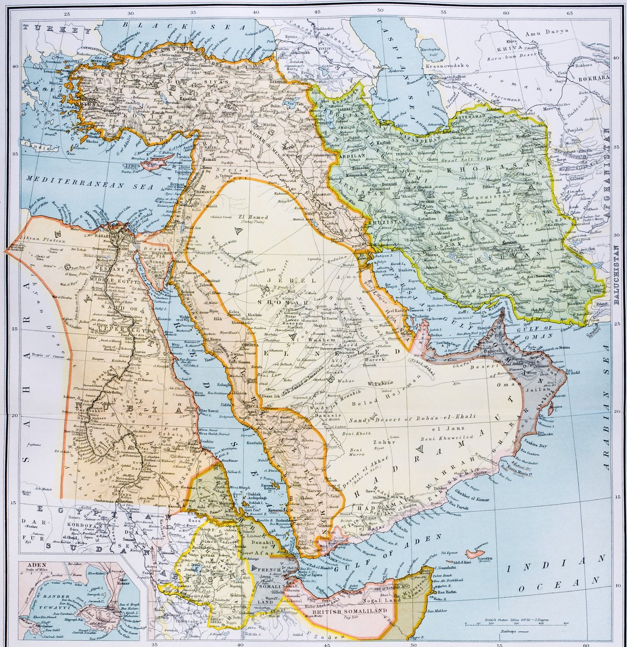
.jpg "Osittainen Lähi-idän kartta 1890-luvulta, teoksesta \"The Citizen")


.jpg "Länsi-Asien")


.jpg "Lähi-idän osittainen kartta 1890-luvulta, teoksesta \"Kansalaisen maailmankartasto\", julkaistu Lontoossa, noin 1899")
.jpg "Turkki Aasiassa, Vähä -Aasiassa ja Transkaukasiassa.")


.jpg "Vähä-Aasia, Kaukasus ja Mustameri.")
.jpg "Imperia Persarum ja Macedonum.")


.jpg "Kanaan eli Palestiina Uuden testamentin aikana")
.jpg "Turkin, Arabian ja Persian kartta Guillaume de L")
.jpg "Imperia Persarum ja Macedonum")
.jpg "Kirkko ja mökki valaistuine ikkunoineen")


.jpg "Kuningas Rikhard III:n muotokuva")
 c1740-50 - (MeisterDrucke-77045).jpg "Kidbrooke Park, Kent, aiemmin George Lambert (1700–1765) n. 1740–50.")


.jpg "Yksityiskohtainen kartta Gallipolin niemimaasta ja Dardanelleista, Turkki, 1915, julkaisusta \"The War Illustrated Album de Luxe\", julkaistu Lontoossa, 1916")


.jpg "Maailmankartta, jossa Brittiläisen imperiumin alueet on väritetty punaisiksi, noin 1870")


 (detail of - (MeisterDrucke-363656).jpg "Venetsian kartta, 1600-luvun alkupuolisko (yksityiskohta teoksesta 64062)")
 - (MeisterDrucke-153535).jpg "Cambridgeshiren kartta, julkaistu Amsterdamissa n. 1647-48 (käsinvärinen kaiverrus)")

.jpg "Ms. Arabe 2221, fol. 203 ja 204, Välimeren, Euroopan ja Afrikan kartta, 1300")
 c1574-75 - (MeisterDrucke-58063).jpg "Kartta 1500-luvun Euroopasta teoksesta \"Sala del Mappamondo\" (Maailmankarttojen sali), noin 1574-75")
.jpg "Martiniquen saaren kartta, 1599")
 - (MeisterDrucke-136393).jpg "Uuden-Englannin ja New Yorkin kartta John Speedin teoksesta \"Theatre of the Empire of Great Britain\", 1676")

 - (MeisterDrucke-45630).jpg "Läntisen Välimeren kartta (muste pergamentille)")

 pub by Joannes Janssonius Amsterdam 1660-61 (hand coloured eng - (MeisterDrucke-90743).jpg "Eteläisen pallonpuoliskon kartta teoksesta \"The Celestial Atlas, or The Harmony of the Universe\", julkaissut Joannes Janssonius, Amsterdam, 1660-61")
 - (MeisterDrucke-79678).jpg "Vähän-Aasian kartta, jossa näkyvät Norja, Ruotsi, Tanska, Lappi, Puola, Turkki, Venäjä ja Moskovan alue, noin 1626")
 pub by Joannes Janssonius A - (MeisterDrucke-52996).jpg "Julius Schillerin kuvaamien kristillisten tähdistöjen kartta teoksesta \"Taivaallinen atlas eli maailmankaikkeuden harmonia\" (Atlas coelestis seu harmonia macrocosmica), julkaisija Joannes Janssonius, A")
 pub by Joannes Janssonius Amsterdam 1660-61 - (MeisterDrucke-193066).jpg "Kartta Kuun kiertoradan kartoittamisesta Maan ympäri, pubista \"A Celestial Atlas tai The Harmony of the Universe\" (Atlas coelestis seu harmonia macrocosmica). Joannes Janssonius, Amsterdam, 1660-61")
.jpg "Tähtitieteilijä, yksityiskohta planeettojen kartalta, pubista \"A Celestial Atlas, or The Harmony of the Universe\" (Atlas coelestis seu harmonia macrocosmica). kirjoittanut Joannes Janssonius, Amsterdam, 1660-61 (ha")

.jpg "Kaksitoista auringonkukkaa maljakossa")
.jpg "Kristuksen ylösnousemus, Isenheimin alttarin oikeasta siivestä, noin 1512-16, yksityiskohta teoksesta 17677")
.jpg "Langlois")
.jpg "Ilta iirispellolla")
.jpg "Vaaleanpunainen korostus, 1926")


.jpg "Napoleon ylittää Alpit")
.jpg "Kooste Cresquesin Katalonian maailmankartaston 8 sivusta: tuolloin tunnettu maailma")

.jpg "Niittyjä Greifswaldin lähellä")
.jpg "Männyt")
.jpg "Epäilevä Tuomas, 1602-03")
.jpg "Vapahtaja. Deesis-rivistä")

 +43 4257 29415
 support@meisterdrucke.com
 Mo-Do: 7:00 - 16:00 | Fr: 7:00 - 13:00